


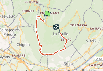
monthoux > la Thuile

catduv
User

Length
10.9 km

Max alt
1292 m

Uphill gradient
756 m
Km-Effort
21 km

Min alt
783 m

Downhill gradient
666 m
Boucle
No
Creation date :
2025-06-17 07:17:36.537
Updated on :
2025-06-17 13:50:10.932
3h48
Difficulty : Difficult

FREE GPS app for hiking
 SityTrail
IGN / Geographical institutes
SityTrail Plus
The world is yours!
About
Trail Walking of 10.9 km to be discovered at Auvergne-Rhône-Alpes, Savoy, La Thuile. This trail is proposed by catduv.
Positioning
Country:
France
Region :
Auvergne-Rhône-Alpes
Department/Province :
Savoy
Municipality :
La Thuile
Location:
Unknown
Start:(Dec)
Start:(UTM)
268509 ; 5047760 (32T) N.
Comments